
Living Root Bridge
The ninety kilometre or so drive from Shillong in the direction of Mawlynnong took us over three hours, what with the condition of the roads and the occasional traffic snarl on narrow passes. The winding road led us south along a majestic mountaintop route through Langkyrdem, Pynursla and Pongtung in the direction of the Bangladesh border.

At each village, churches loomed out of scale and Fitzcarraldo-like.


At Mawlynnong (declared the cleanest village in Asia by Discover India magazine in 2003) a straggling but steady flow of tourists gathered at the only restaurant open on this Sunday. The visitors were mostly Indian, and in fact here we met the only two non-Indian tourists on our whole visit to the Hills (from France and China).
VIDEO FOOTAGE OF THE DRIVE TO AND FROM SHILLONG, AND THE LIVING ROOT BRIDGE NEAR RIWAI
The bridge at Wahthyllong, twenty minutes walk down stone steps from Riwai village, is probably over a century old, formed from the knitted aerial roots of two Indian Banyan trees (Ficus benghalensis) on opposing sides of the stream, a marvellous symbiosis of humans and the natural environment. Here women come to wash clothes in the river, and the bridle paths disappearing up each side of the valley connect village with village and link the region in a network of trade routes.
A young Henry Yule, then a Lieutenant in the Bengal artillery and later co-author of Hobson-Jobson, was possibly the first European to describe the living root bridges of the Khasi Hills (‘Notes on the Kasia Hills, and People’, Journal of the Asiatic Society of Bengal 13, 2 [1844], new series: 613).
The bridge by which we cross is worthy of description, as I believe no account of any thing similar has yet been published.
On the top of a huge boulder by the river side, grows a large India rubber tree, clasping the stone in its multitude of roots. Two or three of the long fibres, whilst still easily pliable, have been stretched across the stream, and their free ends fastened on the other bank. There they have struck firmly into the earth, and now form a living bridge of great, and yearly increasing strength. Two great roots run directly one over the other, and the secondary shoots from the upper have been bound round, and grown into the lower, so that the former affords at once a hand-rail and suspending chain, the latter a footway. Other roots have been laced and twisted into a sort of ladder as an ascent from the bank to the bridge. The greatest thickness of the upper root is a foot, from which it tapers to six or eight inches. The length of the bridge is above eighty feet, and its height about twenty above the water in the dry season.
The bridge was constructed by the people of the village of Ringhot, and forms their communication with Cherra during the rains; the present generation say, it was made by their grandfathers. This was the first and most remarkable bridge of the kind that I saw in the Kasia Hills, and I supposed it to be unique, perhaps half accidental. But, I afterwards found it to be an instance of a regular practice, and saw such bridges in every stage, from that of two slender fibres hung across the stream, to such as I have tried to describe above, and there are not less than half a dozen within as many miles of Cherra. One* I measured ninety feet in clear span. They were generally composed of the roots of two opposite trees, (apparently planted for the purpose), bound together in the middle.
*Shewn in Plate 1.

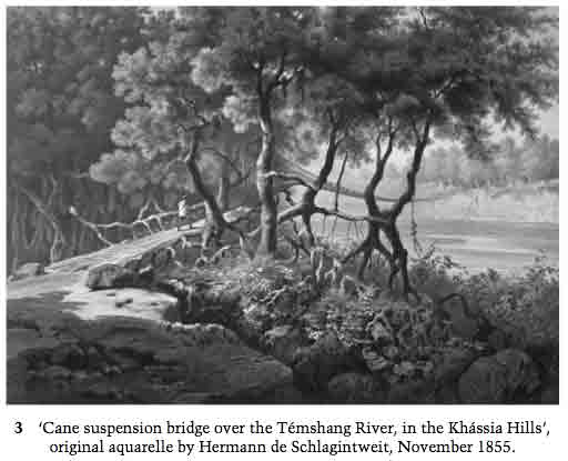
This seems to be the same bridge described by the Schlagintweits (Plate 5 in H. Schlagintweit et al., Results of a Scientific Mission to India and High Asia, undertaken between the years 1854 and 1858, by order of the Court of Directors of the Honourable East India Company Atlas, Part I, Leipzig; London, F.A. Brockhaus; Trübner & Co., 1861), though it’s unclear to me where in the present-day is the Temshang/Temshung river.
Cane suspension bridge over the Témshang River, in the Khássia Hills
Geographical Coordinates: 25.13.0 91.43.0
These bridges, which present a characteristic feature in the scenery of eastern jungles, are constructed of cane, secured to the banks at either end by the ramifications of the aerial roots of the figtree, and various other tropical trees. Though light and elastic in their materials, they are quite strng enough to bear the weight of a man carrying a heavy load, but, when of any considerable length, the vibration renders the passage over them very difficult. The length of the bridge is 312 feet, its height above the water 62 feet. The depth of the river exceeds in its central parts 30 feet.

Recent Comments